Berth 1: Grains
LOCATION: right margin of the Parana River, Km.330
LATITUDE: 33 ş 27.285 'south. LENGTH: 2.327 ş 60 'West.
OWNERS Bunge Argentina S.A.
ADDRESS: Camino de la Costa Km 4.7 - Ramallo - Buenos Aires - Argentina.
Activity Develops: Loading Cereals, flours in bulk
Type of Vessel operating: Panamax / Handy Size
Load mobilized: Cereals, flour in bulk.
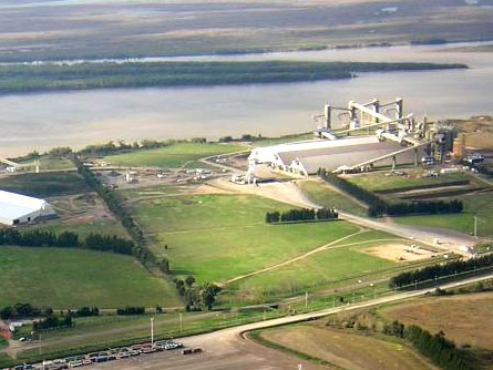
OVERVIEW OF YOUR DESIGN: consists of 4 towers connected boarding 3 together by metal walkways and 3 galleries of shipment, the package is communicated with mainland by a footbridge and a gallery of metal transfer from the tower Shipment No. 2 to tower scale. It also has 4 Dolphins berthing and mooring towers 2 for long.
Features access to water:
Channel: Yeah, right margin of the Parana River, 330 km.
Width of river: 800 m
Navigable with: 270 m.
Zero depth to the local scale: 20 m.
Signaling system for navigation: conventional Beacons.
Beacons: If, visibility 2.5 km
Pilotage: Compulsory for entry and exit, Port and River pilots.
Trailers: No.
Characteristics of land access: Camino de la Costa Km 4.7, with direct access to Highway
Buenos Aires - Rosario.
CAPACITY Location: Vessels of 50,000 gross tons, 273 meters long .
Loading rate: 3,000 tons. / Hs. Grains - 2,000 tons. / Hs. Byproducts / Fertilizers too.
Geographical position: Latitude E 33 ş 26 '57.4 "Longitude W 60 ° 0.2" 46.2 ".
Location: right margin of the Parana River, Km.330.
OWNER: S. Bunge Argentina A.
ADDRESS: Camino de la Costa Km 4.7 - Ramallo - Buenos Aires - Argentina.
Type of Vessel operating: barges and ships in bulk.
Load mobilized: Download bulk and liquid fertilizers.
Features access to water:
Channel: Yeah, right margin of the Parana River, Km.330.
Width of river: 800 m
Navigable with: 270 m.
Zero depth to the local scale: 20 m.
OVERVIEW OF YOUR DESIGN: It consists of three Dolphins berth, two towers mooring and five Dolphins support of the metal structure supporting the transfer belt and feed hoppers. CAPACITY Location: Vessels of 40,000 gross tons, 223 m in length and 30 m in breadth
DEPTH WALKING SPRING: 11.10 m.
Characteristics of land access: Camino de la Costa Km 4.7, with direct access to Highway
Buenos Aires - Rosario.
Signaling system for navigation: conventional Beacons.
Pilotage: Compulsory for entry and exit, River and Port Pilots.
Trailers: No.
Characteristics of land access: Located at Km 4.7 of the route known as Camino de Costa (formerly Route No. 9) which connects the coastal city of Ramallo Town / Village in San Nicolás de los Arroyos, has direct access to Highway Buenos Aires - Rosario Pedro Eugenio Aramburu "through National Route N ° 9.
Download speed: 300 - 400 tons. / Hs. Bulk - 250 - 300 tons. / Hs. liquid